Planning for Kerikeri's growth
- By Rod Brown
- Jun 7, 2018
- 3 min read
Are we using the correct population data set?
Population trends should be a key pillar in planning for and managing future infrastructure needs.
Historically planning has been a challenge for Kerikeri. We seem to be perennially ‘behind the eight ball’ with critical infrastructure generally failing to keep pace with the demands from the population growth of both the town and its broader residential ‘catchment’ area. Waste water and roading are two areas that have struggled for many years.
Making sure that we are using current and the correct baseline data for planning assumptions is a critical starting point.
The FNDC Long Term Plan (LTP), that has recently gone through its consultation phase, uses 2013 census data and measures the population of Kerikeri as two statistical areas comprising Kerikeri Township and Kerikeri Township Surrounds as shown in the IDNZ map (below). In 2013 the population of this combined area was 6,500. The most recent estimate (2018) shows a growth of 16.5% to 7,575.

A critical omission from this base population assumption are the nearby communities that are an integral part of Kerikeri. None have shops or facilities and residents must come into to Kerikeri and/or Waipapa for shopping, services, school and many for employment. Using outdated 2013 census data, these areas (table below) account for a further 3,594 ‘residents’ who do impact on Kerikeri infrastructure such as roads, parking and recreational facilities and contribute to traffic congestion.
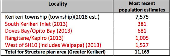
But this figure of 11,169 still does not fully reflect the overall population that relies on the town for services such as medical and schooling. Taking enrolled patient numbers with Kerikeri medical practices as an example, Kerikeri is servicing about 16,300 people or roughly 27% of the population of the entire Far North District. Traffic congestion is very apparent at certain times of the day along Kerikeri Road which has 11,000 traffic movements a day (April 2016 data) and associated parking problems.
The appropriate planning basis for Kerikeri is the Kerikeri/Waipapa Structure Plan area (map area outlined in red - below) which was adopted by Council in 2007. This encompasses a more realistic population catchment (‘let's call it Greater Kerikeri’) that must access Kerikeri services, facilities, shops, schools and social activities on a regular basis.

The estimated population of Kerikeri and Surrounds (area outlined in green) in 2018 is 7,575 and is forecast to grow by 25% by 2043 (Source IDNZ) to 9,526 which ignores the current additional 47.4% population that lies outside the 'Kerikeri and Surrounds' area. The “Greater Kerikeri” area already has an estimated population of at least 11,169 people so that 2043 forecast (9,526) grossly underestimates total growth and future impacts.
While the draft LTP does include three new roads which were included in the largely ignored 2007 Kerikeri/Waipapa Structure Plan and which we welcome, that does not represent a cohesive plan for the growth of Kerikeri.
What is not in the Draft FNDC Long Term Plan
Apart from the proposed three new roads and the current sewerage project for central Kerikeri, the 2018-2028 LTP response to growth in Kerikeri and surrounds is not programmed until after 2028.
Kerikeri needs an integrated development plan
We need to transition from the Structure Plan which is a concept, via District Plan, LTP & funding programs to an integrated plan from our history of ad hoc decision making.
The LTP does not address:
Waipapa wastewater - not planned until 2040
A Riverview wastewater plan
Parking in CBD is under strain
Traffic management at the Kerikeri Rd/Hobson Ave roundabout
A plan & vision for the CBD (after having first built the Kerikeri Ring Road)
Encourage residents to consider alternate transport especially for shorter trips by offering separated, safe cycle lanes.
Broader traffic network planning
Links to IDNZ profiles and maps


